Sound Navigation
In past articles, I have pointed out many of the decorative components a nautical chart mural offers to a home or office. A nice feature of having a nautical chart expanded to fit a wall is being able to see better the incredible number of details that are found within the chart. Here's another element to enjoy - seeing where helpful "sounds" can be found.
Charts are wonderful because they confirm your navigational skills on the water. You set a course, follow it, and Presto! You close in on a landmark where you alter your course – just like you plotted it on your chart. And if you are careful, you won’t run into submerged rocks, go aground, or wander carelessly into a busy shipping lane, because your chart warns you of these dangers.
And then the fog sets in!
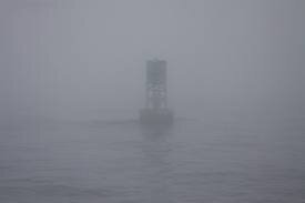
Now all you can see is your bow. Barely. And your compass. And you can plot your speed. So now you are using dead reckoning, going from your last known position to your next based on your knowledge of boat speed, compass heading, and what the current is doing at the time. Good luck sailor!
But your chart is still useful and will give you sound advice! You see, there are aids to navigation that are marked by more than a physical presence or the lighted aids to navigation, when those guiding red, green and white lights do not penetrate the fog very well.
Thankfully, sound does travel fairly well over water. And your chart will show you the nearby aids to navigation marked by three different sounds. Those sounds are: BELL, HORN and GONG. Why three? So that you can tell one from another in conditions of limited visibility and thus help you plot a course to a safe port.
When fog causes a loss of vision, just remember: Your chart will tell you which of the three sounds to listen for in helping to guide you through the pea soup. So listen up! There’s a horn, bell, or gong trying to get you back to your home harbor!